
This newsletter drop summarizes my first real trip to the Ozarks National Forest. If you follow the YouTube channel, this will likely answer any questions you had about locations, camp conditions, and points of interest within the video. If you are not a subscriber but are planning a trip this will provide a good starting point and inspiration.
Destinations
~Ozarks National Forest
This forest covers 1.2 million acres of thick woods full of hardwood and pine trees, turquoise river streams and waterfalls. There are plenty of scenic dispersed campsites and most importantly wheeling trails full of mud, water crossings, and don’t forget branches waiting to deliver fresh pinstripes to your rig.
Campsite Location One
~ We started this trip at Haw Creek Falls recreation area. This was a nice free established campground nestled next to a river with a little waterfall. There are about ten camp spots in a roundabout fashion with enough space for two vehicles comfortably.
Campsite coordinates: 35°40'37.2"N 93°15'18.0"W

Waterfall by campsite
Campsite accessibility
~ This area is easily accessible by paved roads. The area is good for late night arrivals to the Ozarks. It is close to many trails which can be embarked on the following morning. This is how we used the camp area as it is a five hour drive from Texas.
Trails and Route
~ Again this was more of a pit stop before we explored the wild of the Ozarks, so the trails and route to this place can be reached from the highway .
Campsite Location Two
~ The last campsite of the trip was out of pure desperation. We originally planned to camp at an established campground called White Rock Mountain campground but we arrived too late and the camp manager was not helpful at all so we had to leave even though there were plenty of spots open. Things like this are all apart of the journey so we ended just camping off of the forest service road.
Campsite coordinates: 35°41'53.2"N 93°58'07.3"W

Last Resort Campsite off White Rock Mtn road
Campsite accessibility
~ This site is right off the road on the way to the White Rock Mtn recreation area. This campsite wasn’t really planned it was really just a place to sleep for the night. No great views or anything special. As they say The journey is the real reason for the adventure not the destination. In this case that was true.
Trails and Route
~ The trail we started off with was Car Wash falls. This trail is nothing technical other than a small water crossing. For a couple of rookies like us the water crossing looked a little intimidating but it turned out to be nothing serious.
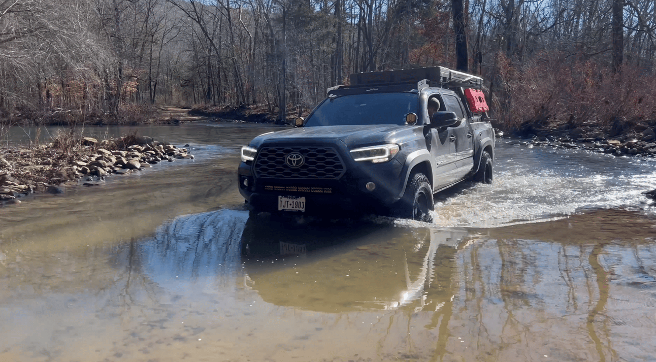
Water Crossing on Car Wash falls trail
The water crossing is at the start of the trail if you start on the end we did. If you cross over a one lane bridge before the start of the trail you will be going the same direction. As I mentioned earlier the trail is not technically difficult but it offers amazing views of the river and a lot of huge boulders and rock formations along the cliff. One of the protruding rocks from the cliffside of the trail is what provides the waterfall that has made the trail famously known as car wash falls.

Car Wash waterfall
Mid-way through the trail is a really cool spot along the Big Piney river. This spot would offer a cool place to stay for multiple rigs. We stopped here for awhile to take in the views and make a couple casts with the fly rod.
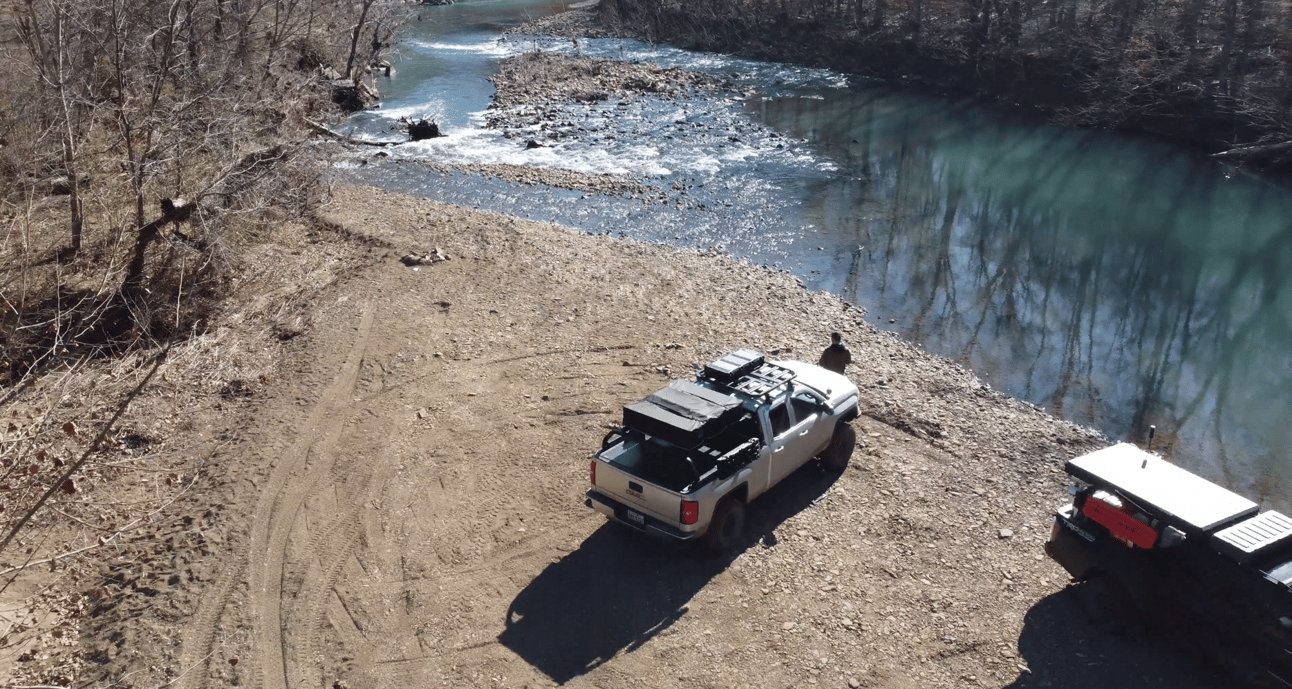
Big Piney Campsite
From there we finished the trail and made our way to the Whitaker point hiking trail. It was good to stretch the legs and get some miles under our feet. The end of the trail leads to a stunning view.

Whitaker Point peak
After completing the hike, the long journey to find a campsite began. I lost track of what trails we were on but one of the highlights for me was the deep water crossing we came across as it was getting dark. Both of us were really nervous about it but making it through boosted our off-roading confidence and made the journey even better.

Deep Water Crossing (for me)
As I mentioned earlier we tried to camp at the established campground on white rock mountain. We arrived thirty minutes after they closed and the park attendant was not having it. So, we camped along the road just outside of the recreation area. This is one reason I don’t like established campgrounds but we wanted a nice view. Its all apart of the experience and the trip was a success in my book.


Points of interest
~ Carwash Falls trail was my favorite area of this trip. There are several nice campsites along the way with one providing great river access. The coordinates for the start of the trail are below
Trail Coordinates: 35.67733, -93.2348
~ Whitaker Point Hike is a good and short manageable hike that provides a rewarding view at the end. Definitely recommend checking it out if you would like to stretch the legs and give the rig a break.
Whitaker Hiking Trail Coordinates: 35.898477, -93.457874
Gear notes
~ The Hcalory diesel heater was the star of the show for this trip. With the temps dipping into the high twenties this heater kept me nice and warm all night. I haven’t had any issues with this heater and would recommend it to anyone in the market for one. Keep in mind with cheaper products comes cheaper quality control so experiences may vary.
Amazon link: https://amzn.to/4jcnhL8

Diesel Heater fired up
Scripture of the month:
Do not be anxious about anything, but in every situation, by prayer and petition, with thanksgiving, present your requests to God. And the peace of God, which transcends all understanding, will guard your hearts and your minds in Christ Jesus.
Philippians 4 : 6-7
Link to video below: